


Mine de L’Eguisse

Renefrt
User
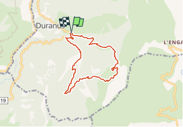

Length
7.5 km

Max alt
963 m

Uphill gradient
576 m
Km-Effort
15.2 km

Min alt
385 m

Downhill gradient
584 m
Boucle
Yes
Creation date :
2025-05-14 14:55:45.0
Updated on :
2025-05-14 14:55:47.96
3h27
Difficulty : Difficult

FREE GPS app for hiking
 SityTrail
IGN / Geographical institutes
SityTrail Plus
The world is yours!
About
Trail Walking of 7.5 km to be discovered at Provence-Alpes-Côte d'Azur, Maritime Alps, Duranus. This trail is proposed by Renefrt.
Positioning
Country:
France
Region :
Provence-Alpes-Côte d'Azur
Department/Province :
Maritime Alps
Municipality :
Duranus
Location:
Unknown
Start:(Dec)
Start:(UTM)
360734 ; 4861295 (32T) N.
Comments