


Sainte Cécile 10km à pied

v.hanosset
User
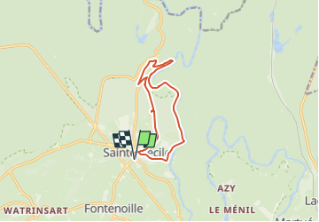

Length
10.2 km

Max alt
379 m

Uphill gradient
215 m
Km-Effort
13.1 km

Min alt
279 m

Downhill gradient
215 m
Boucle
Yes
Creation date :
2025-05-14 15:53:10.896
Updated on :
2025-05-18 08:39:44.825
2h58
Difficulty : Difficult

FREE GPS app for hiking
 SityTrail
IGN / Geographical institutes
SityTrail Plus
The world is yours!
About
Trail Walking of 10.2 km to be discovered at Wallonia, Luxembourg, Florenville. This trail is proposed by v.hanosset.
Positioning
Country:
Belgium
Region :
Wallonia
Department/Province :
Luxembourg
Municipality :
Florenville
Location:
Unknown
Start:(Dec)
Start:(UTM)
661643 ; 5510733 (31U) N.
Comments