Rando 1..15/05/2025..Groupe Larzac

boubou68
User
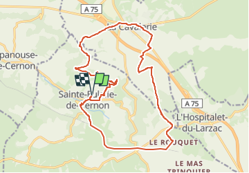

Length
21 km

Max alt
870 m

Uphill gradient
541 m
Km-Effort
28 km

Min alt
575 m

Downhill gradient
540 m
Boucle
Yes
Creation date :
2025-05-14 16:55:37.973
Updated on :
2025-05-14 16:55:41.229
6h25
Difficulty : Very difficult

FREE GPS app for hiking
 SityTrail
IGN / Geographical institutes
SityTrail Plus
The world is yours!
About
Trail Walking of 21 km to be discovered at Occitania, Aveyron, Sainte-Eulalie-de-Cernon. This trail is proposed by boubou68.
Positioning
Country:
France
Region :
Occitania
Department/Province :
Aveyron
Municipality :
Sainte-Eulalie-de-Cernon
Location:
Unknown
Start:(Dec)
Start:(UTM)
511036 ; 4870082 (31T) N.
Comments