


Lauzerte vers Dufort

simonm0204
User
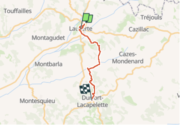

Length
14.3 km

Max alt
231 m

Uphill gradient
402 m
Km-Effort
19.6 km

Min alt
101 m

Downhill gradient
406 m
Boucle
No
Creation date :
2025-05-15 06:49:05.0
Updated on :
2025-05-15 13:06:23.668

FREE GPS app for hiking
 SityTrail
IGN / Geographical institutes
SityTrail Plus
The world is yours!
About
Trail of 14.3 km to be discovered at Occitania, Tarn-et-Garonne, Lauzerte. This trail is proposed by simonm0204.
Description
Étape du Gr 65
Positioning
Country:
France
Region :
Occitania
Department/Province :
Tarn-et-Garonne
Municipality :
Lauzerte
Location:
Unknown
Start:(Dec)
Start:(UTM)
351430 ; 4901937 (31T) N.
Comments