


pressiat mont myon

loca.yves
User GUIDE
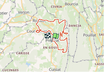

Length
16.9 km

Max alt
658 m

Uphill gradient
741 m
Km-Effort
27 km

Min alt
251 m

Downhill gradient
741 m
Boucle
Yes
Creation date :
2025-05-15 07:56:06.461
Updated on :
2025-05-15 14:32:55.723
6h36
Difficulty : Very difficult

FREE GPS app for hiking
 SityTrail
IGN / Geographical institutes
SityTrail Plus
The world is yours!
About
Trail Walking of 16.9 km to be discovered at Auvergne-Rhône-Alpes, Ain, Val-Revermont. This trail is proposed by loca.yves.
Description
difficile
Positioning
Country:
France
Region :
Auvergne-Rhône-Alpes
Department/Province :
Ain
Municipality :
Val-Revermont
Location:
Unknown
Start:(Dec)
Start:(UTM)
683536 ; 5132515 (31T) N.
Comments