


thin michel

labotte
User
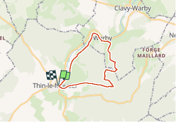

Length
10.9 km

Max alt
289 m

Uphill gradient
230 m
Km-Effort
13.9 km

Min alt
170 m

Downhill gradient
229 m
Boucle
Yes
Creation date :
2025-05-15 11:41:25.327
Updated on :
2025-05-15 14:42:51.38
3h00
Difficulty : Easy

FREE GPS app for hiking
 SityTrail
IGN / Geographical institutes
SityTrail Plus
The world is yours!
About
Trail Walking of 10.9 km to be discovered at Grand Est, Ardennes, Thin-le-Moutier. This trail is proposed by labotte.
Positioning
Country:
France
Region :
Grand Est
Department/Province :
Ardennes
Municipality :
Thin-le-Moutier
Location:
Unknown
Start:(Dec)
Start:(UTM)
608437 ; 5508450 (31U) N.
Comments