


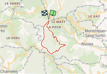
Saint-Cyr-le-Chatoux (9,7 km - D. 384 m)

Thomasdanielle
User

Length
9.7 km

Max alt
866 m

Uphill gradient
384 m
Km-Effort
14.8 km

Min alt
515 m

Downhill gradient
383 m
Boucle
Yes
Creation date :
2025-05-15 12:16:17.0
Updated on :
2025-05-17 10:22:43.057
3h22
Difficulty : Difficult

FREE GPS app for hiking
 SityTrail
IGN / Geographical institutes
SityTrail Plus
The world is yours!
About
Trail Walking of 9.7 km to be discovered at Auvergne-Rhône-Alpes, Rhône, Saint-Cyr-le-Chatoux. This trail is proposed by Thomasdanielle.
Description
D/A : Parking à droite en rentrant dans village, pratiquement au départ de la randonnée.
Très belle vue sur le plateau.
Positioning
Country:
France
Region :
Auvergne-Rhône-Alpes
Department/Province :
Rhône
Municipality :
Saint-Cyr-le-Chatoux
Location:
Unknown
Start:(Dec)
Start:(UTM)
620485 ; 5098010 (31T) N.
Comments