


Rif Didier 15052025

dblix
User
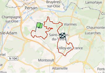

Length
30 km

Max alt
212 m

Uphill gradient
558 m
Km-Effort
37 km

Min alt
42 m

Downhill gradient
470 m
Boucle
No
Creation date :
2025-05-15 06:43:12.0
Updated on :
2025-05-15 18:22:09.021
10h57
Difficulty : Very difficult

FREE GPS app for hiking
 SityTrail
IGN / Geographical institutes
SityTrail Plus
The world is yours!
About
Trail Walking of 30 km to be discovered at Ile-de-France, Val-d'Oise, Presles. This trail is proposed by dblix.
Positioning
Country:
France
Region :
Ile-de-France
Department/Province :
Val-d'Oise
Municipality :
Presles
Location:
Unknown
Start:(Dec)
Start:(UTM)
447986 ; 5440326 (31U) N.
Comments