


Fleurieu sur Saône

vazitonton
User
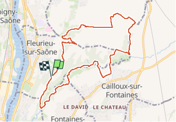

Length
11.7 km

Max alt
294 m

Uphill gradient
284 m
Km-Effort
15.5 km

Min alt
201 m

Downhill gradient
283 m
Boucle
Yes
Creation date :
2025-05-15 11:37:56.475
Updated on :
2025-05-15 18:38:58.974
3h05
Difficulty : Difficult

FREE GPS app for hiking
 SityTrail
IGN / Geographical institutes
SityTrail Plus
The world is yours!
About
Trail Walking of 11.7 km to be discovered at Auvergne-Rhône-Alpes, Métropole de Lyon, Fleurieu-sur-Saône. This trail is proposed by vazitonton.
Positioning
Country:
France
Region :
Auvergne-Rhône-Alpes
Department/Province :
Métropole de Lyon
Municipality :
Fleurieu-sur-Saône
Location:
Unknown
Start:(Dec)
Start:(UTM)
643560 ; 5079730 (31T) N.
Comments