Trail Walking Grèzes - TOUR DU MONTCHOUVET 43 - circuit pédestre les noisettes sauvages - Photo

TOUR DU MONTCHOUVET 43 - circuit pédestre les noisettes sauvages

 jeff66
jeff66

User

© OpenStreetMap contributors
Length
Length
18.1 km
Max alt
Max alt
1481 m
Uphill gradient
Uphill gradient
495 m
Km-Effort
Km-Effort  
25 km
Min alt
Min alt
1116 m
Downhill gradient
Downhill gradient
497 m
Boucle
Boucle
Yes
Creation date :
2015-07-17 00:00:00.0
Updated on :
2015-07-17 00:00:00.0

(0 Reviews)

Walking
Walking
4h13
Difficulty : Difficult

Scan this QR Code to open this trail in the SityTrail application

FREE GPS app for hiking

Logo SityTrail SityTrail

IGN / Geographical institutes

Download SityTrail from the App Store Download SityTrail from Google Play

Logo SityTrail SityTrail World

The world is yours!

Download SityTrail from the App Store Download SityTrail from Google Play Download SityTrail on Huawei AppGallery

About

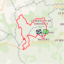
Trail Walking of 18.1 km to be discovered at Auvergne-Rhône-Alpes, Haute-Loire, Grèzes. This trail is proposed by jeff66.

Description

TOUR DU MONTCHOUVET 43 - départ entre Bugeac et Le Menial - chante perdrix - les Bartes - le suc - zouriat - Poutarelle - vue sur Servieres - Le Courniet - site archéologique - les Hivers - le Soubirot - le MONTCHOUVET - Ronc de Chazeyrat - D 33 - Combe -

Elevation profile

Photos

Positioning

Country:
France
Region :
Auvergne-Rhône-Alpes
Department/Province :
Haute-Loire
Municipality :
Grèzes
Location:
Unknown
Start:(UTM)
535625 ; 4973767 (31T) N.

Trails nearby

Trail On foot Paulhac-en-Margeride - La Molle - Photo
On foot
guitounette

On foot

Easy
(2)
Paulhac-en-Margeride, Occitania, Lozère, France
8.5 km | 12 km-effort
2h 42min
Yes
Trail Walking Grèzes - CC_Velay_AC_03_Grezes_St-Alban-Limagnole_20060823 - Photo
Walking
patrickdanilo

Walking

Medium
Grèzes, Auvergne-Rhône-Alpes, Haute-Loire, France
26 km | 34 km-effort
6h 15min
No
Trail Walking Grèzes - Mon Compostelle deuxième étape - Photo
Walking
Ardeiserois

Walking

Very difficult
Grèzes, Auvergne-Rhône-Alpes, Haute-Loire, France
57 km | 73 km-effort
11h 15min
No
Trail Walking Venteuges - Pontajou très facile loup - Photo
Walking
billyg

Walking

Very easy
Venteuges, Auvergne-Rhône-Alpes, Haute-Loire, France
4.5 km | 6.1 km-effort
1h 15min
Yes
Trail Equestrian Le Malzieu-Forain - MAJ 21 DRAILLE EN MARGERIDE 2eme partie vers Saugues - Photo
Equestrian
Lozère Cheval

Equestrian

Very easy
Le Malzieu-Forain, Occitania, Lozère, France
50 km | 64 km-effort
Unknown
Yes
Trail Walking Chanaleilles - 3 Saugues Le Sauvage - Photo
Walking
pzvictor

Walking

Easy
Chanaleilles, Auvergne-Rhône-Alpes, Haute-Loire, France
8.2 km | 11.6 km-effort
2h 38min
No
Trail Walking Chanaleilles - Le Villeret-Le Sauvage - Photo
Walking
parrotdad

Walking

Easy
Chanaleilles, Auvergne-Rhône-Alpes, Haute-Loire, France
9.1 km | 12.6 km-effort
3h 17min
No
Trail Walking Chanaleilles - Le Villeret d'Apcher - Aumont Aubrac - Photo
Walking
avangaver

Walking

Medium
Chanaleilles, Auvergne-Rhône-Alpes, Haute-Loire, France
26 km | 35 km-effort
Unknown
No
Trail Walking Chanaleilles - 2023 05 19 - Chanaleilles - Saint Alban - Photo
Walking
lolomilastef

Walking

Very difficult
(1)
Chanaleilles, Auvergne-Rhône-Alpes, Haute-Loire, France
18.1 km | 24 km-effort
5h 26min
No


Close
My subscriptions