


Dan47 - 2026 Membre - Pont de claies.

istadaniel
User
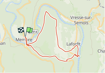

Length
8.8 km

Max alt
315 m

Uphill gradient
291 m
Km-Effort
12.7 km

Min alt
176 m

Downhill gradient
292 m
Boucle
Yes
Creation date :
2025-05-16 11:33:58.971
Updated on :
2025-05-16 11:36:12.468
2h53
Difficulty : Difficult

FREE GPS app for hiking
 SityTrail
IGN / Geographical institutes
SityTrail Plus
The world is yours!
About
Trail Walking of 8.8 km to be discovered at Wallonia, Namur, Vresse-sur-Semois. This trail is proposed by istadaniel.
Positioning
Country:
Belgium
Region :
Wallonia
Department/Province :
Namur
Municipality :
Vresse-sur-Semois
Location:
Unknown
Start:(Dec)
Start:(UTM)
636635 ; 5525539 (31U) N.
Comments