


Trace G3 Rustrel Guy 160525

mitch1952
User
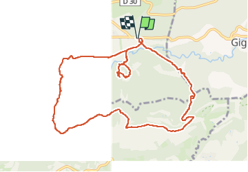

Length
11.9 km

Max alt
574 m

Uphill gradient
297 m
Km-Effort
15.9 km

Min alt
329 m

Downhill gradient
297 m
Boucle
Yes
Creation date :
2025-05-16 08:09:16.0
Updated on :
2025-05-16 13:03:18.461

FREE GPS app for hiking
 SityTrail
IGN / Geographical institutes
SityTrail Plus
The world is yours!
About
Trail of 11.9 km to be discovered at Provence-Alpes-Côte d'Azur, Vaucluse, Rustrel. This trail is proposed by mitch1952.
Positioning
Country:
France
Region :
Provence-Alpes-Côte d'Azur
Department/Province :
Vaucluse
Municipality :
Rustrel
Location:
Unknown
Start:(Dec)
Start:(UTM)
700691 ; 4866010 (31T) N.
Comments