


Poubazlanec

FOUCAULT
User

Length
4.7 km

Max alt
58 m

Uphill gradient
91 m
Km-Effort
5.9 km

Min alt
1 m

Downhill gradient
88 m
Boucle
Yes
Creation date :
2025-05-16 14:48:05.0
Updated on :
2025-05-16 17:28:22.097
1h37
Difficulty : Unknown

FREE GPS app for hiking
 SityTrail
IGN / Geographical institutes
SityTrail Plus
The world is yours!
About
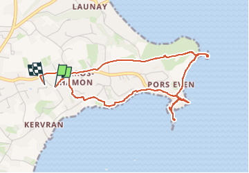
Trail Walking of 4.7 km to be discovered at Brittany, Côtes-d'Armor, Ploubazlanec. This trail is proposed by FOUCAULT.
Description
Le 16 mai 2025
Photos


Positioning
Country:
France
Region :
Brittany
Department/Province :
Côtes-d'Armor
Municipality :
Ploubazlanec
Location:
Unknown
Start:(Dec)
Start:(UTM)
498441 ; 5405296 (30U) N.
Comments