


boucle de Vollardonnel

Mascart
User
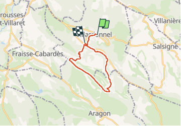

Length
9.9 km

Max alt
374 m

Uphill gradient
211 m
Km-Effort
12.8 km

Min alt
220 m

Downhill gradient
243 m
Boucle
No
Creation date :
2025-05-16 06:42:15.504
Updated on :
2025-05-16 17:33:49.531
3h00
Difficulty : Medium

FREE GPS app for hiking
 SityTrail
IGN / Geographical institutes
SityTrail Plus
The world is yours!
About
Trail Walking of 9.9 km to be discovered at Occitania, Aude, Villardonnel. This trail is proposed by Mascart.
Description
via la Valouvière et Capservy
Positioning
Country:
France
Region :
Occitania
Department/Province :
Aude
Municipality :
Villardonnel
Location:
Unknown
Start:(Dec)
Start:(UTM)
444271 ; 4798254 (31T) N.
Comments