


RD-Le-Fort-des-Rousses

raymondfn
User
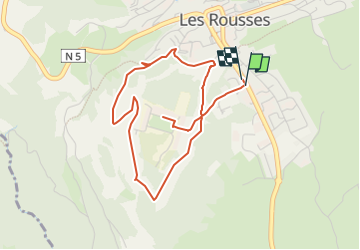

Length
4.7 km

Max alt
1142 m

Uphill gradient
82 m
Km-Effort
5.8 km

Min alt
1094 m

Downhill gradient
84 m
Boucle
Yes
Creation date :
2025-05-16 17:52:08.162
Updated on :
2025-05-16 18:01:41.692
1h19
Difficulty : Easy

FREE GPS app for hiking
 SityTrail
IGN / Geographical institutes
SityTrail Plus
The world is yours!
About
Trail Walking of 4.7 km to be discovered at Bourgogne-Franche-Comté, Jura, Les Rousses. This trail is proposed by raymondfn.
Positioning
Country:
France
Region :
Bourgogne-Franche-Comté
Department/Province :
Jura
Municipality :
Les Rousses
Location:
Unknown
Start:(Dec)
Start:(UTM)
274506 ; 5151751 (32T) N.
Comments
