


gerde

brunobuj
User
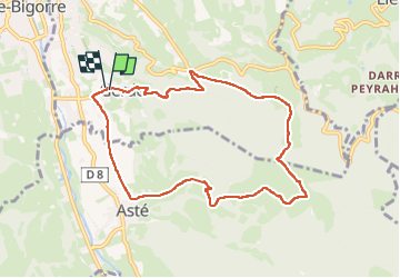

Length
9.2 km

Max alt
1011 m

Uphill gradient
439 m
Km-Effort
15.1 km

Min alt
573 m

Downhill gradient
443 m
Boucle
Yes
Creation date :
2025-05-17 12:17:18.518
Updated on :
2025-05-17 14:30:12.683
2h12
Difficulty : Medium

FREE GPS app for hiking
 SityTrail
IGN / Geographical institutes
SityTrail Plus
The world is yours!
About
Trail Nordic walking of 9.2 km to be discovered at Occitania, Hautespyrenees, Gerde. This trail is proposed by brunobuj.
Description
rando
Positioning
Country:
France
Region :
Occitania
Department/Province :
Hautespyrenees
Municipality :
Gerde
Location:
Unknown
Start:(Dec)
Start:(UTM)
269195 ; 4770850 (31T) N.
Comments