


Tarn et Jonte J7

Mariolebeno
User
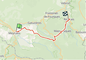

Length
22 km

Max alt
1252 m

Uphill gradient
724 m
Km-Effort
32 km

Min alt
701 m

Downhill gradient
660 m
Boucle
No
Creation date :
2025-05-17 07:24:09.212
Updated on :
2025-05-17 14:38:23.38
5h15
Difficulty : Medium

FREE GPS app for hiking
 SityTrail
IGN / Geographical institutes
SityTrail Plus
The world is yours!
About
Trail Walking of 22 km to be discovered at Occitania, Lozère, Meyrueis. This trail is proposed by Mariolebeno.
Positioning
Country:
France
Region :
Occitania
Department/Province :
Lozère
Municipality :
Meyrueis
Location:
Unknown
Start:(Dec)
Start:(UTM)
534854 ; 4892070 (31T) N.
Comments