


Tournadous - Guilhaumard

Alain28/01
User
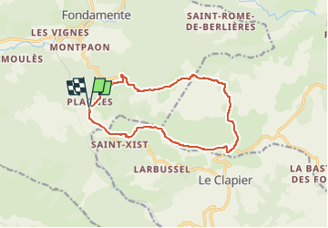

Length
13.7 km

Max alt
798 m

Uphill gradient
261 m
Km-Effort
17.1 km

Min alt
625 m

Downhill gradient
258 m
Boucle
Yes
Creation date :
2025-05-17 20:09:38.791
Updated on :
2025-05-17 20:10:44.767
3h53
Difficulty : Difficult

FREE GPS app for hiking
 SityTrail
IGN / Geographical institutes
SityTrail Plus
The world is yours!
About
Trail Walking of 13.7 km to be discovered at Occitania, Aveyron, Fondamente. This trail is proposed by Alain28/01.
Positioning
Country:
France
Region :
Occitania
Department/Province :
Aveyron
Municipality :
Fondamente
Location:
Unknown
Start:(Dec)
Start:(UTM)
509741 ; 4855320 (31T) N.
Comments