


Gr 652 Loubressac Floirac

taguette
User
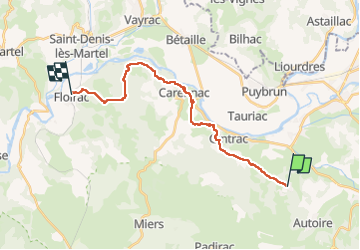

Length
21 km

Max alt
338 m

Uphill gradient
510 m
Km-Effort
28 km

Min alt
122 m

Downhill gradient
700 m
Boucle
No
Creation date :
2025-05-17 06:33:15.131
Updated on :
2025-05-18 06:52:06.633
6h32
Difficulty : Very difficult

FREE GPS app for hiking
 SityTrail
IGN / Geographical institutes
SityTrail Plus
The world is yours!
About
Trail Walking of 21 km to be discovered at Occitania, Lot, Loubressac. This trail is proposed by taguette.
Positioning
Country:
France
Region :
Occitania
Department/Province :
Lot
Municipality :
Loubressac
Location:
Unknown
Start:(Dec)
Start:(UTM)
405452 ; 4969344 (31T) N.
Comments