


Dan47 - 2026 Mellery

istadaniel
User
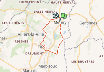

Length
9.1 km

Max alt
159 m

Uphill gradient
117 m
Km-Effort
10.6 km

Min alt
111 m

Downhill gradient
113 m
Boucle
Yes
Creation date :
2025-05-18 07:38:55.88
Updated on :
2025-05-18 07:40:05.257
2h24
Difficulty : Medium

FREE GPS app for hiking
 SityTrail
IGN / Geographical institutes
SityTrail Plus
The world is yours!
About
Trail Walking of 9.1 km to be discovered at Wallonia, Walloon Brabant, Villers-la-Ville. This trail is proposed by istadaniel.
Positioning
Country:
Belgium
Region :
Wallonia
Department/Province :
Walloon Brabant
Municipality :
Villers-la-Ville
Location:
Unknown
Start:(Dec)
Start:(UTM)
611064 ; 5604499 (31U) N.
Comments