


Lac D'Oô, lac d'Espingo et de Saussat

lebarça
User
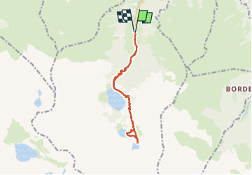

Length
15.1 km

Max alt
1973 m

Uphill gradient
979 m
Km-Effort
28 km

Min alt
1131 m

Downhill gradient
979 m
Boucle
Yes
Creation date :
2025-05-18 07:11:15.0
Updated on :
2025-06-03 09:17:03.031
7h14
Difficulty : Medium

FREE GPS app for hiking
 SityTrail
IGN / Geographical institutes
SityTrail Plus
The world is yours!
About
Trail Walking of 15.1 km to be discovered at Occitania, Haute-Garonne, Oô. This trail is proposed by lebarça.
Positioning
Country:
France
Region :
Occitania
Department/Province :
Haute-Garonne
Municipality :
Oô
Location:
Unknown
Start:(Dec)
Start:(UTM)
295585 ; 4737725 (31T) N.
Comments