


Tarn et Jonte J8

Mariolebeno
User
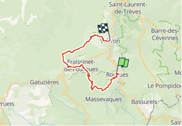

Length
24 km

Max alt
1108 m

Uphill gradient
898 m
Km-Effort
36 km

Min alt
649 m

Downhill gradient
1022 m
Boucle
No
Creation date :
2025-05-18 06:43:39.67
Updated on :
2025-06-02 14:28:04.814
5h55
Difficulty : Difficult

FREE GPS app for hiking
 SityTrail
IGN / Geographical institutes
SityTrail Plus
The world is yours!
About
Trail Walking of 24 km to be discovered at Occitania, Lozère, Rousses. This trail is proposed by Mariolebeno.
Positioning
Country:
France
Region :
Occitania
Department/Province :
Lozère
Municipality :
Rousses
Location:
Unknown
Start:(Dec)
Start:(UTM)
546859 ; 4894980 (31T) N.
Comments