


Sentier des sources

Claudele
User

Length
12.6 km

Max alt
165 m

Uphill gradient
77 m
Km-Effort
13.6 km

Min alt
151 m

Downhill gradient
77 m
Boucle
Yes
Creation date :
2015-07-16 00:00:00.0
Updated on :
2015-07-16 00:00:00.0
4h27
Difficulty : Very easy

FREE GPS app for hiking
 SityTrail
IGN / Geographical institutes
SityTrail Plus
The world is yours!
About
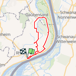
Trail Walking of 12.6 km to be discovered at Grand Est, Bas-Rhin, Rhinau. This trail is proposed by Claudele.
Positioning
Country:
France
Region :
Grand Est
Department/Province :
Bas-Rhin
Municipality :
Rhinau
Location:
Unknown
Start:(Dec)
Start:(UTM)
404481 ; 5352032 (32U) N.
Comments
top d+