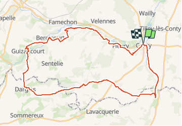
Les 7 côtes

ORTAX
User

Length
42 km

Max alt
198 m

Uphill gradient
636 m
Km-Effort
51 km

Min alt
56 m

Downhill gradient
642 m
Boucle
Yes
Creation date :
2025-05-18 16:38:36.0
Updated on :
2025-05-18 16:38:41.028
3h30
Difficulty : Medium

FREE GPS app for hiking
 SityTrail
IGN / Geographical institutes
SityTrail Plus
The world is yours!
About
Trail Mountain bike of 42 km to be discovered at Hauts-de-France, Somme, Conty. This trail is proposed by ORTAX.
Positioning
Country:
France
Region :
Hauts-de-France
Department/Province :
Somme
Municipality :
Conty
Location:
Conty
Start:(Dec)
Start:(UTM)
438824 ; 5510158 (31U) N.
Comments