


32-Pont d'Arc à Vallon(G2)

lmc
User
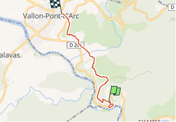

Length
4.8 km

Max alt
247 m

Uphill gradient
222 m
Km-Effort
7.7 km

Min alt
85 m

Downhill gradient
220 m
Boucle
No
Creation date :
2025-05-18 19:29:23.244
Updated on :
2025-05-18 19:29:24.89
1h45
Difficulty : Medium

FREE GPS app for hiking
 SityTrail
IGN / Geographical institutes
SityTrail Plus
The world is yours!
About
Trail Walking of 4.8 km to be discovered at Auvergne-Rhône-Alpes, Ardèche, Vallon-Pont-d'Arc. This trail is proposed by lmc.
Positioning
Country:
France
Region :
Auvergne-Rhône-Alpes
Department/Province :
Ardèche
Municipality :
Vallon-Pont-d'Arc
Location:
Unknown
Start:(Dec)
Start:(UTM)
612570 ; 4915402 (31T) N.
Comments