


Tongres Mulkerstraat

castorgris
User
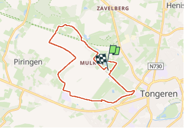

Length
7.5 km

Max alt
113 m

Uphill gradient
70 m
Km-Effort
8.4 km

Min alt
71 m

Downhill gradient
71 m
Boucle
No
Creation date :
2025-05-19 07:39:19.0
Updated on :
2025-05-19 09:45:31.523

FREE GPS app for hiking
 SityTrail
IGN / Geographical institutes
SityTrail Plus
The world is yours!
About
Trail of 7.5 km to be discovered at Flanders, Limburg, Tongeren. This trail is proposed by castorgris.
Positioning
Country:
Belgium
Region :
Flanders
Department/Province :
Limburg
Municipality :
Tongeren
Location:
Tongeren
Start:(Dec)
Start:(UTM)
672461 ; 5629033 (31U) N.
Comments