


Mont Sec, Monjean, Pléney, col de la Madeleine

JMFr
User
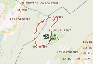

Length
7.2 km

Max alt
1165 m

Uphill gradient
421 m
Km-Effort
12.9 km

Min alt
744 m

Downhill gradient
427 m
Boucle
Yes
Creation date :
2025-05-19 07:52:36.315
Updated on :
2025-05-19 11:06:42.574
2h05
Difficulty : Easy

FREE GPS app for hiking
 SityTrail
IGN / Geographical institutes
SityTrail Plus
The world is yours!
About
Trail Walking of 7.2 km to be discovered at Auvergne-Rhône-Alpes, Isère, Séchilienne. This trail is proposed by JMFr.
Positioning
Country:
France
Region :
Auvergne-Rhône-Alpes
Department/Province :
Isère
Municipality :
Séchilienne
Location:
Unknown
Start:(Dec)
Start:(UTM)
721073 ; 4994604 (31T) N.
Comments