


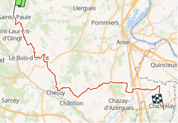
Ste Paule > Plantin via Bagnols / Les chères

aeldin
User

Length
32 km

Max alt
539 m

Uphill gradient
559 m
Km-Effort
40 km

Min alt
177 m

Downhill gradient
836 m
Boucle
No
Creation date :
2025-05-19 13:24:45.473
Updated on :
2025-05-19 14:43:15.138
5h19
Difficulty : Difficult

FREE GPS app for hiking
 SityTrail
IGN / Geographical institutes
SityTrail Plus
The world is yours!
About
Trail Horseback riding of 32 km to be discovered at Auvergne-Rhône-Alpes, Rhône, Sainte-Paule. This trail is proposed by aeldin.
Positioning
Country:
France
Region :
Auvergne-Rhône-Alpes
Department/Province :
Rhône
Municipality :
Sainte-Paule
Location:
Unknown
Start:(Dec)
Start:(UTM)
621224 ; 5091308 (31T) N.
Comments