


st martin de palières /mareliers

bernir
User
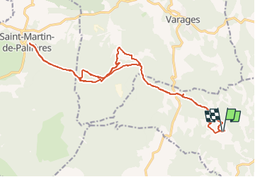

Length
23 km

Max alt
575 m

Uphill gradient
523 m
Km-Effort
30 km

Min alt
339 m

Downhill gradient
523 m
Boucle
Yes
Creation date :
2025-05-19 13:02:54.529
Updated on :
2025-05-27 06:37:59.051
2h04
Difficulty : Easy

FREE GPS app for hiking
 SityTrail
IGN / Geographical institutes
SityTrail Plus
The world is yours!
About
Trail Mountain bike of 23 km to be discovered at Provence-Alpes-Côte d'Azur, Var, Barjols. This trail is proposed by bernir.
Positioning
Country:
France
Region :
Provence-Alpes-Côte d'Azur
Department/Province :
Var
Municipality :
Barjols
Location:
Unknown
Start:(Dec)
Start:(UTM)
740680 ; 4827008 (31T) N.
Comments