


St Jean du Puy tr 2025

inuit
User
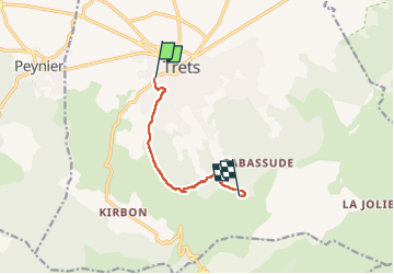

Length
6.4 km

Max alt
646 m

Uphill gradient
396 m
Km-Effort
10.4 km

Min alt
266 m

Downhill gradient
20 m
Boucle
No
Creation date :
2025-05-16 07:39:38.458
Updated on :
2025-05-20 04:57:07.542
4h45
Difficulty : Medium

FREE GPS app for hiking
 SityTrail
IGN / Geographical institutes
SityTrail Plus
The world is yours!
About
Trail Walking of 6.4 km to be discovered at Provence-Alpes-Côte d'Azur, Bouches-du-Rhône, Trets. This trail is proposed by inuit.
Positioning
Country:
France
Region :
Provence-Alpes-Côte d'Azur
Department/Province :
Bouches-du-Rhône
Municipality :
Trets
Location:
Unknown
Start:(Dec)
Start:(UTM)
716625 ; 4813658 (31T) N.
Comments