


seul Dorlisheim

jean charles daniel.
User
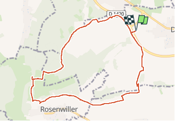

Length
10.3 km

Max alt
352 m

Uphill gradient
240 m
Km-Effort
13.5 km

Min alt
194 m

Downhill gradient
240 m
Boucle
Yes
Creation date :
2025-05-20 07:05:31.626
Updated on :
2025-05-20 09:31:24.756
2h25
Difficulty : Medium

FREE GPS app for hiking
 SityTrail
IGN / Geographical institutes
SityTrail Plus
The world is yours!
About
Trail Walking of 10.3 km to be discovered at Grand Est, Bas-Rhin, Dorlisheim. This trail is proposed by jean charles daniel..
Description
vigne et forêts
Positioning
Country:
France
Region :
Grand Est
Department/Province :
Bas-Rhin
Municipality :
Dorlisheim
Location:
Unknown
Start:(Dec)
Start:(UTM)
386873 ; 5375713 (32U) N.
Comments