


combe Laval fond d'urles

Vedett26
User
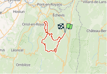

Length
53 km

Max alt
1441 m

Uphill gradient
1366 m
Km-Effort
71 km

Min alt
849 m

Downhill gradient
1368 m
Boucle
Yes
Creation date :
2025-05-20 07:15:15.127
Updated on :
2025-05-20 11:07:06.817
3h51
Difficulty : Very difficult

FREE GPS app for hiking
 SityTrail
IGN / Geographical institutes
SityTrail Plus
The world is yours!
About
Trail Road bike of 53 km to be discovered at Auvergne-Rhône-Alpes, Drôme, La Chapelle-en-Vercors. This trail is proposed by Vedett26.
Positioning
Country:
France
Region :
Auvergne-Rhône-Alpes
Department/Province :
Drôme
Municipality :
La Chapelle-en-Vercors
Location:
Unknown
Start:(Dec)
Start:(UTM)
690461 ; 4982220 (31T) N.
Comments