


gr17 libramont bras

patrickmullie
User
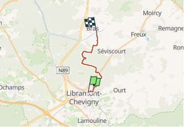

Length
10.4 km

Max alt
576 m

Uphill gradient
186 m
Km-Effort
13 km

Min alt
448 m

Downhill gradient
222 m
Boucle
No
Creation date :
2025-05-19 11:45:36.72
Updated on :
2025-05-20 12:32:31.633
2h44
Difficulty : Very easy

FREE GPS app for hiking
 SityTrail
IGN / Geographical institutes
SityTrail Plus
The world is yours!
About
Trail Walking of 10.4 km to be discovered at Wallonia, Luxembourg, Libramont-Chevigny. This trail is proposed by patrickmullie.
Positioning
Country:
Belgium
Region :
Wallonia
Department/Province :
Luxembourg
Municipality :
Libramont-Chevigny
Location:
Libramont
Start:(Dec)
Start:(UTM)
670992 ; 5532417 (31U) N.
Comments