


gr17 nras bas poix st hubert

patrickmullie
User
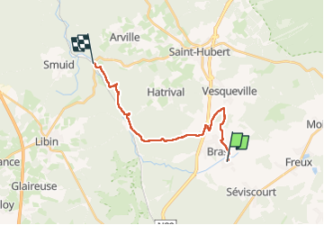

Length
16.6 km

Max alt
554 m

Uphill gradient
261 m
Km-Effort
21 km

Min alt
319 m

Downhill gradient
389 m
Boucle
No
Creation date :
2025-05-20 07:23:42.324
Updated on :
2025-05-20 12:32:34.424
5h08
Difficulty : Easy

FREE GPS app for hiking
 SityTrail
IGN / Geographical institutes
SityTrail Plus
The world is yours!
About
Trail Walking of 16.6 km to be discovered at Wallonia, Luxembourg, Libramont-Chevigny. This trail is proposed by patrickmullie.
Positioning
Country:
Belgium
Region :
Wallonia
Department/Province :
Luxembourg
Municipality :
Libramont-Chevigny
Location:
Unknown
Start:(Dec)
Start:(UTM)
671740 ; 5538145 (31U) N.
Comments