


la fontaine du termanou

Alain34jacou
User
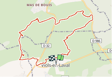

Length
13.9 km

Max alt
315 m

Uphill gradient
189 m
Km-Effort
16.4 km

Min alt
233 m

Downhill gradient
192 m
Boucle
Yes
Creation date :
2025-05-20 07:38:15.565
Updated on :
2025-05-20 12:46:19.292
3h44
Difficulty : Difficult

FREE GPS app for hiking
 SityTrail
IGN / Geographical institutes
SityTrail Plus
The world is yours!
About
Trail Walking of 13.9 km to be discovered at Occitania, Hérault, Viols-en-Laval. This trail is proposed by Alain34jacou.
Description
rando pedestre
Positioning
Country:
France
Region :
Occitania
Department/Province :
Hérault
Municipality :
Viols-en-Laval
Location:
Unknown
Start:(Dec)
Start:(UTM)
558426 ; 4844582 (31T) N.
Comments