


Sylvanes-Larzac

chantalwaltzer
User
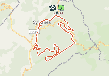

Length
12.2 km

Max alt
686 m

Uphill gradient
412 m
Km-Effort
17.7 km

Min alt
451 m

Downhill gradient
412 m
Boucle
Yes
Creation date :
2025-05-20 07:59:33.0
Updated on :
2025-05-20 13:57:18.343
4h32
Difficulty : Difficult

FREE GPS app for hiking
 SityTrail
IGN / Geographical institutes
SityTrail Plus
The world is yours!
About
Trail Walking of 12.2 km to be discovered at Occitania, Aveyron, Sylvanès. This trail is proposed by chantalwaltzer.
Description
Bien
Positioning
Country:
France
Region :
Occitania
Department/Province :
Aveyron
Municipality :
Sylvanès
Location:
Unknown
Start:(Dec)
Start:(UTM)
497455 ; 4853775 (31T) N.
Comments