


Rando Centuri

Fab-Oz
User

Length
24 km

Max alt
395 m

Uphill gradient
983 m
Km-Effort
37 km

Min alt
0 m

Downhill gradient
983 m
Boucle
Yes
Creation date :
2025-05-20 07:48:32.428
Updated on :
2025-05-20 15:30:47.29
6h54
Difficulty : Difficult

FREE GPS app for hiking
 SityTrail
IGN / Geographical institutes
SityTrail Plus
The world is yours!
About
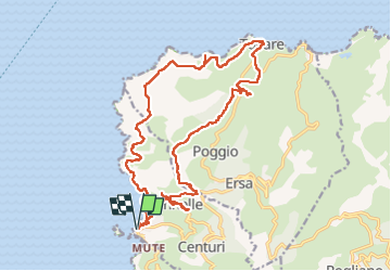
Trail Walking of 24 km to be discovered at Corsica, Haute-Corse, Centuri. This trail is proposed by Fab-Oz.
Description
Départ du port de Centuri
Montée sur le hameau de Cannelle (très joli) puis au moulin de Mattei
Puis continuer jusqu'à Tollare
et retour pour le Sentier des Douaniers
Positioning
Country:
France
Region :
Corsica
Department/Province :
Haute-Corse
Municipality :
Centuri
Location:
Unknown
Start:(Dec)
Start:(UTM)
528366 ; 4756944 (32T) N.
Comments