


Saint Cerice Fontenouille

pb07
User
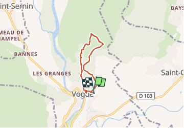

Length
4.7 km

Max alt
273 m

Uphill gradient
90 m
Km-Effort
5.9 km

Min alt
185 m

Downhill gradient
89 m
Boucle
Yes
Creation date :
2025-05-20 12:27:20.433
Updated on :
2025-05-20 16:00:46.906
1h32
Difficulty : Easy

FREE GPS app for hiking
 SityTrail
IGN / Geographical institutes
SityTrail Plus
The world is yours!
About
Trail Walking of 4.7 km to be discovered at Auvergne-Rhône-Alpes, Ardèche, Vogüé. This trail is proposed by pb07.
Positioning
Country:
France
Region :
Auvergne-Rhône-Alpes
Department/Province :
Ardèche
Municipality :
Vogüé
Location:
Unknown
Start:(Dec)
Start:(UTM)
612737 ; 4933934 (31T) N.
Comments