


pont de Lariane - Saint Véran

rochedaniel
User
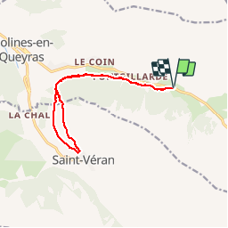

Length
13 km

Max alt
2105 m

Uphill gradient
316 m
Km-Effort
17.2 km

Min alt
1936 m

Downhill gradient
316 m
Boucle
Yes
Creation date :
2015-07-17 00:00:00.0
Updated on :
2015-07-17 00:00:00.0
2h42
Difficulty : Easy

FREE GPS app for hiking
 SityTrail
IGN / Geographical institutes
SityTrail Plus
The world is yours!
About
Trail Walking of 13 km to be discovered at Provence-Alpes-Côte d'Azur, Hautes-Alpes, Molines-en-Queyras. This trail is proposed by rochedaniel.
Photos


Positioning
Country:
France
Region :
Provence-Alpes-Côte d'Azur
Department/Province :
Hautes-Alpes
Municipality :
Molines-en-Queyras
Location:
Unknown
Start:(Dec)
Start:(UTM)
333969 ; 4953876 (32T) N.
Comments