


3 sommets

Vox463
User

Length
17.1 km

Max alt
293 m

Uphill gradient
641 m
Km-Effort
26 km

Min alt
0 m

Downhill gradient
643 m
Boucle
Yes
Creation date :
2025-05-21 06:55:18.12
Updated on :
2025-05-21 06:56:10.049
5h50
Difficulty : Very difficult

FREE GPS app for hiking
 SityTrail
IGN / Geographical institutes
SityTrail Plus
The world is yours!
About
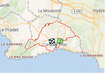
Trail Walking of 17.1 km to be discovered at Provence-Alpes-Côte d'Azur, Var, Carqueiranne. This trail is proposed by Vox463.
Positioning
Country:
France
Region :
Provence-Alpes-Côte d'Azur
Department/Province :
Var
Municipality :
Carqueiranne
Location:
Unknown
Start:(Dec)
Start:(UTM)
262178 ; 4774741 (32T) N.
Comments