


Sevelinges

Pierre Burthier
User
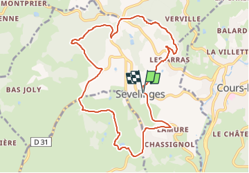

Length
10.4 km

Max alt
671 m

Uphill gradient
324 m
Km-Effort
14.7 km

Min alt
520 m

Downhill gradient
321 m
Boucle
Yes
Creation date :
2025-05-21 08:59:58.019
Updated on :
2025-05-23 08:55:33.605
3h20
Difficulty : Difficult

FREE GPS app for hiking
 SityTrail
IGN / Geographical institutes
SityTrail Plus
The world is yours!
About
Trail Walking of 10.4 km to be discovered at Auvergne-Rhône-Alpes, Loire, Sevelinges. This trail is proposed by Pierre Burthier.
Description
10 km
Positioning
Country:
France
Region :
Auvergne-Rhône-Alpes
Department/Province :
Loire
Municipality :
Sevelinges
Location:
Unknown
Start:(Dec)
Start:(UTM)
600172 ; 5105787 (31T) N.
Comments