


jambles

mcterret
User

Length
5.4 km

Max alt
411 m

Uphill gradient
206 m
Km-Effort
8.1 km

Min alt
264 m

Downhill gradient
211 m
Boucle
Yes
Creation date :
2025-05-21 12:35:03.712
Updated on :
2025-05-21 14:59:20.921
2h23
Difficulty : Easy

FREE GPS app for hiking
 SityTrail
IGN / Geographical institutes
SityTrail Plus
The world is yours!
About
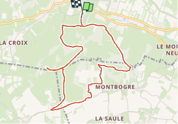
Trail Walking of 5.4 km to be discovered at Bourgogne-Franche-Comté, Saône-et-Loire, Jambles. This trail is proposed by mcterret.
Positioning
Country:
France
Region :
Bourgogne-Franche-Comté
Department/Province :
Saône-et-Loire
Municipality :
Jambles
Location:
Unknown
Start:(Dec)
Start:(UTM)
629598 ; 5181031 (31T) N.
Comments