


Montigny les Conde

Jluc02
User

Length
18.5 km

Max alt
226 m

Uphill gradient
274 m
Km-Effort
22 km

Min alt
102 m

Downhill gradient
277 m
Boucle
Yes
Creation date :
2025-05-22 07:04:10.0
Updated on :
2025-05-27 08:38:50.85
5h01
Difficulty : Very difficult

FREE GPS app for hiking
 SityTrail
IGN / Geographical institutes
SityTrail Plus
The world is yours!
About
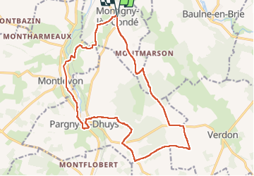
Trail Walking of 18.5 km to be discovered at Hauts-de-France, Aisne, Montigny-lès-Condé. This trail is proposed by Jluc02.
Photos


Positioning
Country:
France
Region :
Hauts-de-France
Department/Province :
Aisne
Municipality :
Montigny-lès-Condé
Location:
Unknown
Start:(Dec)
Start:(UTM)
541539 ; 5426117 (31U) N.
Comments