


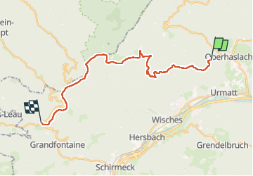
GR53 Oberhaslasch - Col du Donon

emoreau
User

Length
23 km

Max alt
999 m

Uphill gradient
993 m
Km-Effort
35 km

Min alt
309 m

Downhill gradient
614 m
Boucle
No
Creation date :
2025-05-15 06:53:24.301
Updated on :
2025-05-22 12:54:45.435
7h56
Difficulty : Very difficult

FREE GPS app for hiking
 SityTrail
IGN / Geographical institutes
SityTrail Plus
The world is yours!
About
Trail Walking of 23 km to be discovered at Grand Est, Bas-Rhin, Oberhaslach. This trail is proposed by emoreau.
Positioning
Country:
France
Region :
Grand Est
Department/Province :
Bas-Rhin
Municipality :
Oberhaslach
Location:
Unknown
Start:(Dec)
Start:(UTM)
375436 ; 5378602 (32U) N.
Comments