


// Renée Sabran

jmheydorff
User
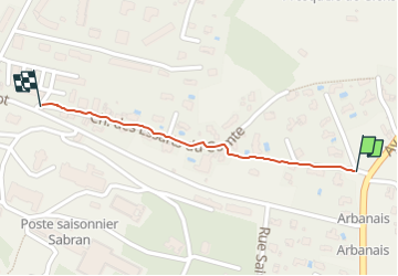

Length
536 m

Max alt
39 m

Uphill gradient
22 m
Km-Effort
776 m

Min alt
15 m

Downhill gradient
6 m
Boucle
No
Creation date :
2025-05-22 13:53:27.317
Updated on :
2025-05-22 14:05:16.056
11m
Difficulty : Very easy

FREE GPS app for hiking
 SityTrail
IGN / Geographical institutes
SityTrail Plus
The world is yours!
About
Trail Nordic walking of 536 m to be discovered at Provence-Alpes-Côte d'Azur, Var, Hyères. This trail is proposed by jmheydorff.
Positioning
Country:
France
Region :
Provence-Alpes-Côte d'Azur
Department/Province :
Var
Municipality :
Hyères
Location:
Unknown
Start:(Dec)
Start:(UTM)
267321 ; 4768886 (32T) N.
Comments