Trail Walking Prondines - ITI0653-R - Photo
 jagarnier
jagarnier

User GUIDE

© OpenStreetMap contributors
Length
Length
10.5 km
Max alt
Max alt
956 m
Uphill gradient
Uphill gradient
252 m
Km-Effort
Km-Effort  
13.9 km
Min alt
Min alt
860 m
Downhill gradient
Downhill gradient
250 m
Boucle
Boucle
Yes
Creation date :
2025-05-23 06:02:50.62
Updated on :
2025-07-13 16:01:24.38

(0 Reviews)

Walking
Walking
3h15
Difficulty : Medium

Scan this QR Code to open this trail in the SityTrail application

FREE GPS app for hiking

Logo SityTrail SityTrail

IGN / Geographical institutes

Download SityTrail from the App Store Download SityTrail from Google Play

Logo SityTrail SityTrail Plus

The world is yours!

Download SityTrail from the App Store Download SityTrail from Google Play Download SityTrail on Huawei AppGallery

About

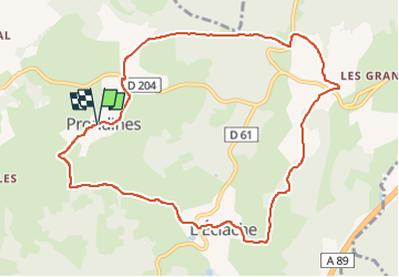
Trail Walking of 10.5 km to be discovered at Auvergne-Rhône-Alpes, Puy-de-Dôme, Prondines. This trail is proposed by jagarnier.

Description

Une randonnée près du bourg de Prondines où l'on découvre des paysages typiques des Combrailles entre forêts de feuillus et prairies. vous verrez aussi les petites chapelles restaurées de Pérol et de l'Eclache qui apportent un charme supplémentaire à cette balade.

Elevation profile

Photos

Positioning

Country:
France
Region :
Auvergne-Rhône-Alpes
Department/Province :
Puy-de-Dôme
Municipality :
Prondines
Location:
Unknown
Start:(UTM)
474837 ; 5067496 (31T) N.


Close
My subscriptions