Trail Walking Saint-Florent - Rando Saint-Florent Saleccia - Photo

Rando Saint-Florent Saleccia

 Fab-Oz
Fab-Oz

User

© OpenStreetMap contributors
Length
Length
22 km
Max alt
Max alt
58 m
Uphill gradient
Uphill gradient
287 m
Km-Effort
Km-Effort  
26 km
Min alt
Min alt
-6 m
Downhill gradient
Downhill gradient
285 m
Boucle
Boucle
No
Creation date :
2025-05-23 06:59:39.824
Updated on :
2025-05-23 13:51:37.695

(0 Reviews)

Walking
Walking
5h19
Difficulty : Medium

Scan this QR Code to open this trail in the SityTrail application

FREE GPS app for hiking

Logo SityTrail SityTrail

IGN / Geographical institutes

Download SityTrail from the App Store Download SityTrail from Google Play

Logo SityTrail SityTrail Plus

The world is yours!

Download SityTrail from the App Store Download SityTrail from Google Play Download SityTrail on Huawei AppGallery

About

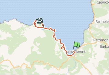
Trail Walking of 22 km to be discovered at Corsica, Haute-Corse, Saint-Florent. This trail is proposed by Fab-Oz.

Description

Au départ du port de Saint-Florent
Sentier du littoral jusqu'à la plage de Lotu, puis la plage de Salaccia et retour jusqu'à Lotu.
Retour en bateau jusqu'à Saint-Florent

A noter qu'on peut gagner presque 3km peu intéressant en se garant vers les campings, juste au début du sentier

Elevation profile

Positioning

Country:
France
Region :
Corsica
Department/Province :
Haute-Corse
Municipality :
Saint-Florent
Location:
Unknown
Start:(UTM)
524340 ; 4725447 (32T) N.


Close
My subscriptions