


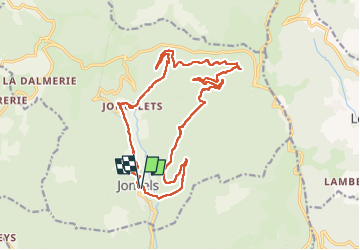
Joncels. Les éoliennes, La Flaissiere Joncelet

Alain28/01
User

Length
21 km

Max alt
713 m

Uphill gradient
612 m
Km-Effort
29 km

Min alt
323 m

Downhill gradient
608 m
Boucle
Yes
Creation date :
2025-05-23 07:32:01.667
Updated on :
2025-05-23 13:52:52.53
4h41
Difficulty : Difficult

FREE GPS app for hiking
 SityTrail
IGN / Geographical institutes
SityTrail Plus
The world is yours!
About
Trail Walking of 21 km to be discovered at Occitania, Hérault, Joncels. This trail is proposed by Alain28/01.
Positioning
Country:
France
Region :
Occitania
Department/Province :
Hérault
Municipality :
Joncels
Location:
Unknown
Start:(Dec)
Start:(UTM)
515718 ; 4842659 (31T) N.
Comments