


Rallye-2505-la-cavee-8-kms-pietons-vtt 5
© OpenStreetMap contributors


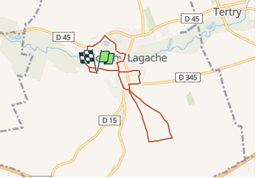
Length
8 km
Max alt
88 m
Uphill gradient
90 m
Km-Effort
9.2 km
Min alt
58 m
Downhill gradient
90 m
Boucle
Yes
Creation date :
2025-05-23 16:15:52.0
Updated on :
2025-05-23 16:15:55.367
FREE GPS app for hiking
 SityTrail
IGN / Geographical institutes
SityTrail Plus
The world is yours!
About
Trail of 8 km to be discovered at Hauts-de-France, Somme, Monchy-Lagache. This trail is proposed by 000037.60b9d4d652fe4cf59f156564421292e4.1539.
Positioning
Country:
France
Region :
Hauts-de-France
Department/Province :
Somme
Municipality :
Monchy-Lagache
Location:
Unknown
Start:(Dec)
Start:(UTM)
502702 ; 5522199 (31U) N.
Comments