


SityTrail - PUGET SUR ARGENS-Lre Cabre- Cabran-DRI

mb83serre
User GUIDE
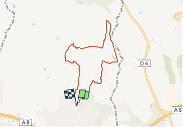

Length
7.5 km

Max alt
68 m

Uphill gradient
88 m
Km-Effort
8.7 km

Min alt
26 m

Downhill gradient
87 m
Boucle
Yes
Creation date :
2025-05-24 10:27:28.412
Updated on :
2025-05-28 16:10:14.598
1h58
Difficulty : Medium

FREE GPS app for hiking
 SityTrail
IGN / Geographical institutes
SityTrail Plus
The world is yours!
About
Trail Walking of 7.5 km to be discovered at Provence-Alpes-Côte d'Azur, Var, Puget-sur-Argens. This trail is proposed by mb83serre.
Description
Depart de la rando parking du Gabre .
COORD GPS.43.4692,6.6925

Positioning
Country:
France
Region :
Provence-Alpes-Côte d'Azur
Department/Province :
Var
Municipality :
Puget-sur-Argens
Location:
Unknown
Start:(Dec)
Start:(UTM)
313349 ; 4815515 (32T) N.
Comments